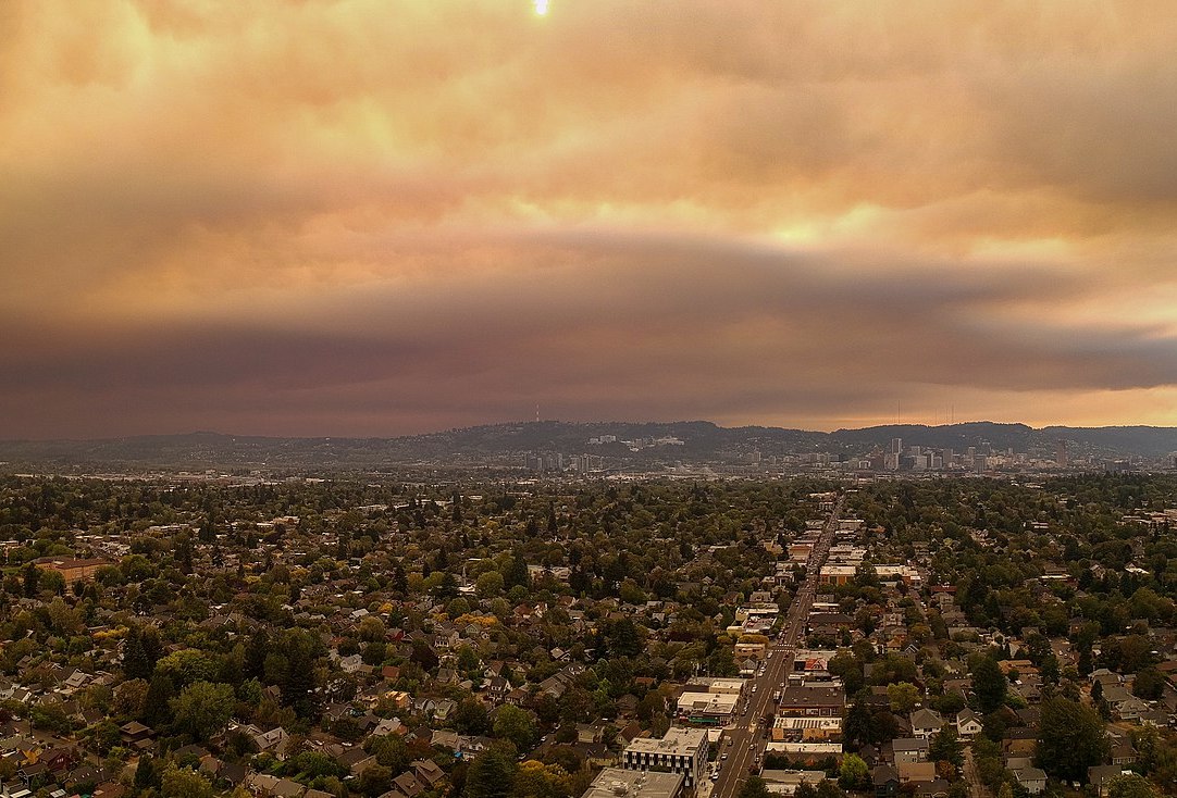
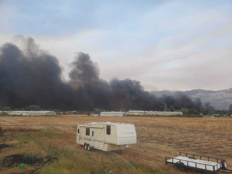
Last week, tragedy struck Oregon, which became the latest state in the western U.S. to experience record-breaking wildfires this summer. At the time of publication, the latest update from the state Office of Emergency Management (OEM) reported that, as of Tuesday, September 15, approximately 1 million acres had burned, at least 8 people have been killed, and 16 individuals are missing. Tens of thousands of people are under some level of evacuation order due to the blazes, which have destroyed hundreds of homes and businesses. Additionally, the state has been plagued by extremely poor air quality due to the fires, with Portland’s Air Quality Index the worst among major cities worldwide in recent days, according to The Oregonian.
One of the country’s top hemp-producing regions is also under threat. Major fires are burning or have burned in Jackson and Josephine Counties, located in Oregon’s Southwestern Valleys. According to a September 11 update from the Oregon Department of Agriculture (ODA), 35% of the state’s 26,365 acres registered for outdoor hemp cultivation are located in the two aforementioned jurisdictions. Based on licensing and acreage data gathered by Hemp Benchmarks this year, Oregon has the fourth most acreage registered for hemp growing of any state, after Colorado, Arizona, and New York.
Bumper Crop Expected Previously
In addition to fires burning in one of America’s premier hemp-growing areas, farmers in the region previously told Hemp Benchmarks that this year was shaping up to be an exceptionally good growing season, a situation we detailed in our August Spot Price Index Report. For example, Mason Walker, CEO of East Fork Cultivars in Takilma, Oregon, told Hemp Benchmarks in an early August interview that the season was progressing “amazingly” and “we expect a bumper crop.” Similar accounts were forthcoming from other growers in the area.
Given the experience of the state’s hemp farmers and the excellent conditions prior to the fires, it is reasonable to assume that yields and product quality out of southern Oregon would have surpassed those of much of the country. Now, however, the current crops, as well as the lives and livelihoods of many operators in the region, are in danger.
Analysis of Grow Sites Threatened by Fires
Hemp Benchmarks employed ODA information on registered hemp grow sites, along with data from the National Interagency Fire Center (NIFC) on fire perimeters and Oregon’s OEM on evacuation zones, to produce the following analysis. Please note that fire perimeter and evacuation zone data can change rapidly. The data below is current as of 2 PM Pacific Standard Time on Tuesday, September 15.
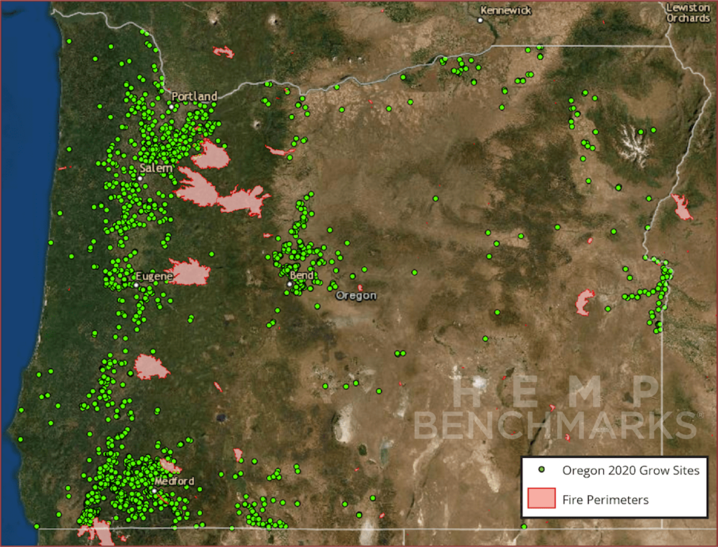
The map above shows the location of hemp grow sites registered with ODA, along with the perimeters of active wildfires as of the time noted above. As of September 11, there were 4,840 hemp grow sites statewide, encompassing 26,365 outdoor acres and over 9.9 million square feet (228 acres) of greenhouse or indoor space.
As of the time specified above, the following grow sites and cultivation areas were within fire perimeters or Level 2 or 3 evacuation zones.
Grow Sites within Fire Perimeters
- 50 sites (1% of statewide total)
- 103 acres (0.4%)
- 99,976 square feet (1%)
Grow Sites within Level 3 Evacuation Zones (Leave Immediately)
- 196 sites (4%)
- 650 acres (2%)
- 721,716 square feet (7%)
Grow Sites within Level 2 Evacuation Zones (Be Set – Prepare to Leave at a Moment’s Notice)
- 576 sites (12%)
- 2,097 acres (8%)
- 1,142,955 square feet (12%)
The data above indicates 17% of grow sites statewide were facing imminent danger from wildfires as of the time of our analysis, encompassing over 10% of Oregon’s registered outdoor acreage and 20% of its indoor / greenhouse square footage.
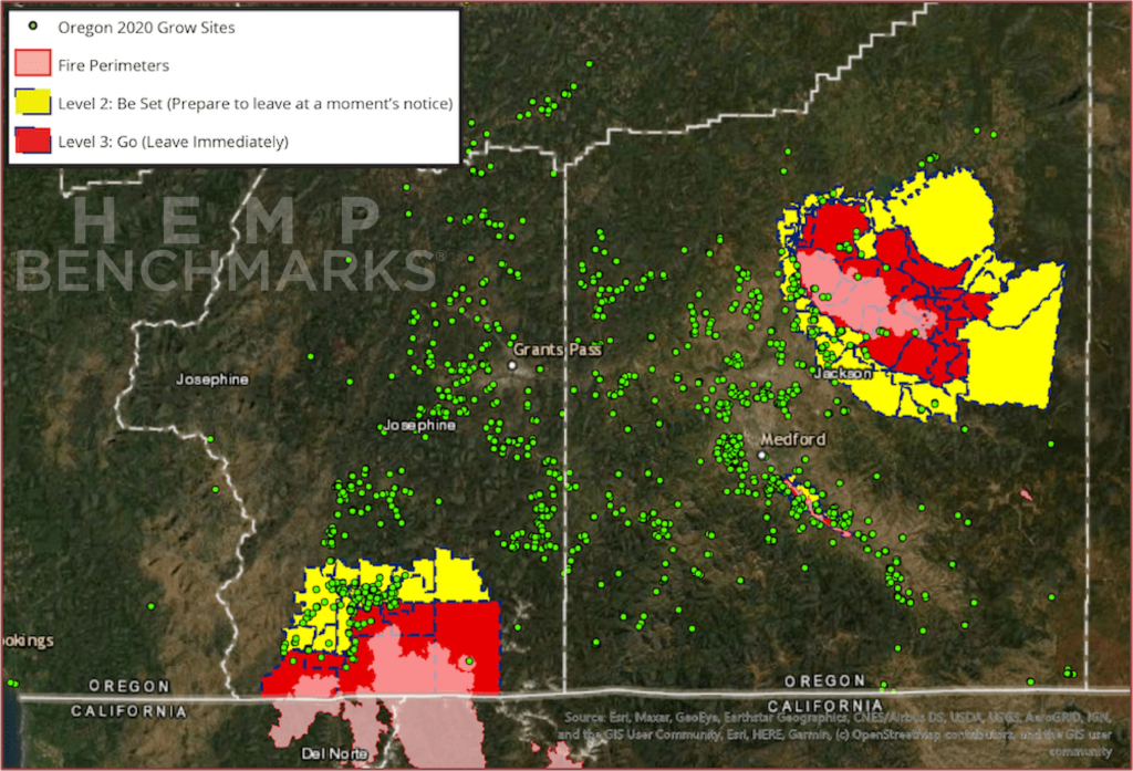
The map above shows registered hemp grow sites in Josephine and Jackson Counties, active fire perimeters, and Level 2 and 3 Evacuation Zones. Readers should note that the data below is included in the statewide data above, rather than in addition to it.
As of September 11, there were 2,238 grow sites in Josephine and Jackson Counties (46% of the statewide total), encompassing 9,145 outdoor acres (35%) and almost 4.8 million square feet of greenhouse or indoor cultivation area (48%). At the time of our analysis, the following numbers of grow sites and cultivation areas in the counties under discussion were within fire perimeters or Level 2 or 3 evacuation zones.
Grow Sites within Fire Perimeters
- 47 sites (2% of those in the two counties; 94% of those within fire perimeters statewide)
- 101 acres (1% of acreage in the two counties; 98% of acreage within fire perimeters statewide)
- 99,000 square feet (2% of square footage in the two counties; 99% of square footage within fire perimeters statewide)
Grow Sites within Level 3 Evacuation Zones (Leave Immediately)
- 88 sites (4% of those in the two counties; 45% of those within Level 3 zones statewide)
- 490 acres (5% of acreage in the two counties; 75% of acreage within Level 3 zones statewide)
- 347,155 square feet (7% of square footage in the two counties; 48% of square footage within Level 3 zones statewide)
Grow Sites within Level 2 Evacuation Zones (Be Set – Prepare to Leave at a Moment’s Notice)
- 345 sites (15% of those in the two counties; 60% of those within Level 2 zones statewide)
- 1,818 acres (20% of acreage in the two counties; 87% of acreage within Level 2 zones statewide)
- 676,016 square feet (14% of square footage in the two counties; 59% of square footage within Level 2 zones statewide)
Over a fifth of grow sites in Josephine and Jackson Counties were in imminent danger at the time of our analysis, encompassing over a quarter of the outdoor acreage and almost a quarter of the greenhouse and indoor square footage registered in the two jurisdictions. As our analysis shows, the threatened hemp farming operations in the two counties account for a significant proportion of those imperiled by the fires statewide.
Damage Not Limited to Burned Crops
Even if farms are not destroyed directly by wildfires, there are unfortunately several other ways in which such disasters can damage or ruin crops. For example, if farmers have to evacuate, they cannot irrigate or otherwise care for their crops. In hot and dry conditions like those in southern Oregon, large, mature hemp plants can wither and die without irrigation.
Steven Fuhr, an Oregon-based hemp processor and multi-state industry consultant, told Hemp Benchmarks the high winds that helped spread the fires were themselves damaging to plants. Fuhr stated that the winds are “the story that got missed in the smoke and fire,” adding, “I know farmers who had 20% to 30% of their crop … blown down.”
Smoke, ash, and other debris thrown up by the conflagrations can land on plants. Fuhr stated that the biggest impact of the smoke and debris from the fires is going to be on the smokable flower market. The extent of damage to crops being grown for smokable flower is uncertain at this point, he said.
One silver lining, according to Fuhr, is that the impact of such contamination on plants intended as biomass for extracting CBD or other cannabinoids is “negligible.” “Processing takes out a lot of the tastes and flavors, good or bad,” Fuhr said. With some crops intended for smokable flower potentially unable to be sold in that form, growers will likely look to have any salvaged plant material processed as biomass.
Infrastructure Damage, Lack of Insurance, and Supply Chain Interruptions May Lead to More Difficulties
Fallout from destructive wildfires and accompanying extreme weather can bring with it additional difficulties. Hemp Benchmarks also spoke with Brandon Dessart, owner of Tip of the Triangle Farm in Talent, Oregon, which grows CBD and CBG hemp on 10 acres. Talent was in the path of the Almeda Fire, which tore through the town, destroying an estimated 600 homes, according to The Oregonian.
Miraculously, Dessart’s farm was unscathed. He told Hemp Benchmarks that the Talent Irrigation District, the municipal authority managing water access, was scheduled to cut off irrigation this week, which is earlier than usual due to drought in the region. However, Dessert said that his access to water had been extended through the end of this week, a decision made by officials so that residents would have water for firefighting purposes if necessary. In other cases, irrigation districts have declared that water for crops is to be diverted for professional firefighting efforts, according to Fuhr.
Dessart also called attention to power outages, which can vary in duration depending on the damage to lines in the area. Dessart echoed Fuhr’s description of high winds, stating that it was a problem that he had been facing for much of the year, with winds reaching around 60 miles per hour helping to feed and spread the fires around his farm.
Dessart noted that he is unsure whether any aid or relief will be forthcoming from state officials. He also stated, “There hasn’t been any decent crop [insurance] coverage here in Oregon the whole time since [hemp] farming became legal,” suggesting that those who have suffered losses may not be covered even if they do hold some form of insurance policy. Regarding insurance for hemp crops, Fuhr stated, “I don’t know anybody that’s got it.”
The fires may also cause testing and supply chain interruptions with the harvest season upon us. Dessart said that numerous extractors and testing facilities in and around Talent had been destroyed by the fires. Hemp Benchmarks was able to verify that at least two testing labs in the area were lost to the blazes. According to a September 9 Facebook post, Pinnacle Analytics in Talent was destroyed and will not be providing tests for the foreseeable future. Additionally, a comparison of Google Maps and satellite images of fire damage in Phoenix, Oregon published by CNN indicate that Ecotest Labs – located in the large, square building at the northeast corner of state Highway 99 and North Phoenix Road – was also among the structures consumed by the flames.
A reduction in lab capacity could slow turnaround times for required testing of hemp in Oregon, which has some of the more stringent standards for hemp and hemp products in the nation. Destroyed or damaged extraction facilities mean that farmers who might have contracted with those operations will have to seek other arrangements, assuming their crops survive.
Hemp Benchmarks will continue reporting on this developing story, with expanded coverage and a more detailed assessment of the wildfires’ impact on hemp production in the region included in this month’s Spot Price Index Report, to be published September 30.
Hemp Benchmarks extends its deepest sympathies to all those impacted by these devastating tragedies. Those who would like to contribute to relief and recovery efforts in Oregon can do so via the Oregon Community Foundation.